
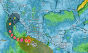
Hurricane Polo remains a powerful Category Four hurricane off the southwestern coast of Mexico, with maximum sustained winds near 155 mph. The storm is currently moving west-northwest away from the immediate southwestern Mexican coastline; however, the forecast track now brings Polo northward toward Baja California Sur later this weekend into Monday/Tuesday of next week.
- Polo is forecast to remain a major hurricane through the weekend before weakening as it approaches and crosses Baja California Sur early next week
- Current guidance indicates the storm could pass over Baja California Sur late Monday into Tuesday, then move into or near the Gulf of California while still producing hurricane-force or tropical storm-force conditions
- Southwestern Mexico remains at risk for additional rain, flooding, mudslides, surf, and coastal logistics delays through today; swells, rough seas, port disruptions, and road delays are expected to expand north toward Baja California Sur over the weekend
- Potential supply issues include harvest interruptions, reduced field access, delayed crossings, transfer delays, and quality concerns tied to moisture, wind, and extended transit time
- Primary items to monitor this week remain avocados and limes from Western Mexico
- Early next week storm exposure could develop for tomatoes, cucumbers, chiles, and other vegetables if rain, wind, or transportation delays increase across Baja California Sur and northwest Mexico
- Markon will continue to monitor the storm track, regional weather impacts, and supplier updates as Polo approaches Baja California Sur early next week
Please contact your Markon Account Manager for more information.
©2026 Markon Cooperative, Inc. All rights reserved.