
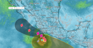
Hurricane Polo strengthened into a Category One hurricane (currently 80mph) off the southwestern coast of Mexico and is expected to intensify quickly through Tuesday. The storm will remain near the coast before turning west-northwest or northwest, bringing heavy rain, surf, and potential logistics disruptions to parts of southwestern Mexico.
- Polo is forecast to rapidly intensify into a major hurricane by Tuesday, September 22, with the potential to quickly build to Category 4 or Category 5 strength by late Tuesday evening
- Early week storm impacts will be focused near Guerrero, Michoacán, Colima, and Jalisco growing regions; at this time, a direct impact on land is not likely
- Rainfall totals of 4 to 8 inches are forecast across coastal Guerrero and Michoacán, with isolated totals up to 12 inches; 3 to 6 inches of rain are possible in coastal Oaxaca, Colima, and Jalisco
- Heavy rainfall may trigger flash flooding, mudslides, road closures, and loading or crossing delays, especially in steep terrain and coastal shipping corridors
- Avocados and limes are the primary items to monitor early this week; chiles, cucumbers, squash, and tomatoes could see potential impacts later in the week if Hurricane Polo veers toward the Baja Peninsula
- Markon will continue to monitor Hurricane Polo and provide updates as the storm tracks and regional supply impacts become clearer
Please contact your Markon Account Manager for more information.
©2026 Markon Cooperative, Inc. All rights reserved.